The Kayts Island Fort (Tamil: ஊர்காவற்றுறைக் கோட்டை, romanized: Ūrkāvaṟṟuṟaik Kōṭṭai; Sinhala: කයිට්ස් දූපත් බලකොටුව Kayits Dupath Balakotuwa) was built by the Portuguese in 1629 and was abandoned in 1651. In the late 1600s, Dutch controlled the fort when they took over the Kayts island. During the Dutch rule, it was not normal to undergo restoration like the former forts of Portugal
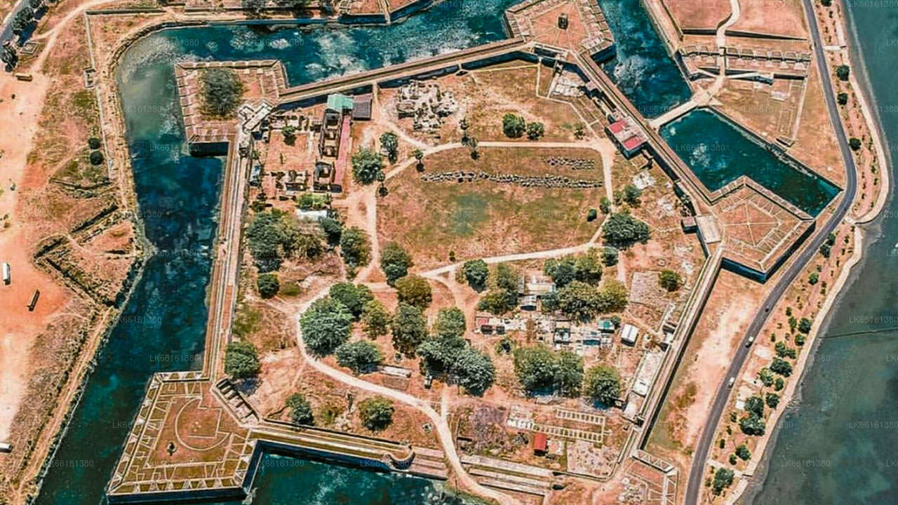
The horseshoe shaped fort with four circular bastions was built to protect Jaffna Peninsula like other Portuguese forts in the peninsula. There was one of the primary commercial ports called “Urundai” beside the fort. Therefore, the fort was known as “Urundai Fort”. The Tamil word “Urundai” literally means sphere or round-shape
Known as Urathota (Uruthota) in the ancient times, Kayts was a major port in ancient Sri Lanka. According to the Nagadeepa Tamil inscription, during the reign of King Parakramabahu I (1153-1186), Urathota was a special port for Indian merchant ships and the king had paid special attention to ships carrying horses and elephants at this port.
Urathota got its name Kayts from the Portuguese. It’s a name derived from “Caes dos Elefantes“. The term means “elephant’s mouth”. The Portuguese came to call this port “Caes dos Elefantes” because Sri Lankan elephants were exported to India through this port. The name “Caes dos Elefantes” was simplified to “Cais“. After the expulsion of the Portuguese and the arrival of the Dutch in Jaffna, the name was further evolved in to “Kays” and later to “Kayts“.
The fort at Kayts was built by the Portuguese. Antonio Bocarro, who served as chronicler-general of the Portuguese State of India has made a note of the fort in 1635. He has called this fort “Fort at the Elephants Quay“. It is said that this fort is as big as the Mannar Fort but better shaped. It has two bastions on the land side and a breastwork on the seaside which is 35 meters long and 5.5 meters wide. It is not filled up, but raised on beams and the open gallery below cannot be protected in any manner because rain water pours in through the openings in the ground for the movement of the artillery. There are twelve open embrasures above at the height, from the ground level, of 2.5 meters and from the parapet of the embrasures upwards is 1.8 meters. The fort was equipped with 8 artillery pieces, three 8 pounders, three 6 pounders and two 5 pounders. There has been enough space for ample ammunition, the captain and 40 soldiers inside this fort.
Baldaeus, a Dutch pastor, writes in his 1672 memoir, states that the Dutch sent a message of surrender to the Portuguese commander in charge of Fort Kayts during the Dutch invasion of Jaffna in 1658. However he does not mention any details of this fort. After taking control of Jaffna, the Dutch did not attempt to rebuild Kayts Fort. This may have been due to the existence of nearby Hammenhiel Fort.
The next information on this fort come from a author using a pen name “PENN”. Penn writing to the Colombo Journal in 1832 reports that the fort was already in ruins when he visited it. At the time, it was known as “Erie Fort“. A study of the ruins revealed that it was a fort 130 feet long with four cylindrical walls and thick walls. It is mentioned that there were two gates on the east and west and part of the outer slope of the fort facing the sea on the north.
According to an article published in 1926 by a British author named J Pearson, the fort, mentioned by PENN at the time, had been largely destroyed. But Pearson has methodically studied these ruins and states that this fort was not square but horseshoe-shaped. Two bastians faced the sea with the convexity facing landwards to the south
The length of the fort is 274 feet to the northern wall joining the bastions. The extreme width is 206 feet. The outer wall of the horse-shoe is 19 feet in thickness and encloses two well defined rectangles, the northern one of which is 116 feet long by 95 feet wide and which undoubtedly acted as a courtyard. The southern portion of the fort was occupied by the residences of the garrison, arranged on three sides of the southern rectangle, which doubtless formed an open courtyard devoted to the more peaceful avocations of the garrison. In all there are ten rooms opening on to this southern courtyard, the dimensions of which are 91 feet by 83 feet.
The northern portion of the fort has outer and inner ramparts, both on the eastern and western sides, separated from each other by an open space 13 feet wide and 160 feet long. The inner wall is extremely interesting as an arched passage runs around it on the outer side, supported at intervals by internal buttresses which project into the passage, thus dividing it into a number of compartments. The rubble of this dilapidated fort have been removed and the current remains are now somewhat preserved
An inscription of archaeological value has been discovered near this fort. The content of this inscription is written in Tamil script and as foll
"Good luck !! At Mathottam (Rajarajapura) in Mannar, Jayankontha alias Muwantha Veler, the commander and general, conquered Sri Lanka and took away King Mahinda and the queen."
King Mahinda mentioned in this inscription appears to be the King Mahinda the 5th (982-1029 AD) who is considered to be the last king of the kingdom of Anuradhapura. The Mahavamsa states that the Cholas invaded the country during the reign of 5th Mahinda (Mahinda), captured King Mahinda’s queen, tricked the king by showing a false show of peace, taking the king prisoner too and sent all the plundered treasure from Ceylon, the king and the queen to India. The Delft inscription confirms the authenticity of this description in the Mahavamsa. This inscription is now kept at the Jaffna Museum.